
Amanda DePasquale
New Zealand Study Abroad W10
1. Whitianga, New Zealand
Whitianga is located in the northern half of the North Island of New Zealand. It is found on the Coromandel Peninsula and is the main town in Mercury Bay. Whitianga is a deep water harbor, great for fishing and scenic cruising. The activities in Whitianga include fishing and catching shellfish, along with water sports. There are also dolphins that swim around in the wharf, and you may get a glimpse of them, if you're lucky. On land, there are many great restaurants, as well as bush walks and horse trails to take part in. From Google Earth, you can see the town of Whitianga which is well-developed, along with the beautiful coastal beaches.
Whitianga was first settled by Kupe, a Maori explorer, and his tribe in 950 A.D. and has been continuously inhabited since then. From the 1800s to the early 1900s, Whitianga was a leading timber port. It is estimated that over sixty years, 500 million feet of kauri was exported. Whitianga was also known for its gum. Gum digging exports began in 1844, and by 1899 over 11,000 tons of kauri gum was exported. The industries that have thrived in Whitianga have included boat building, kauri milling, flax milling, gold mining and gum digging. Today, Whitianga prospers off of tourism, fishing, and farming for its wealth.
The beaches in Mercury Bay and in Whitianga provide a beautiful and scenic area to visit. We will be here from January 8-10. While here, we will get to visit Cathedral Cove, a marine reserve, where we can view naturally formed rock archways. Also, we will visit the Hot Water Beach, where, during low tide, we can dig our own hot pool out of the sand. These hot pools form from the underground superheated water that is stored in basins from previous volcanoes. The water can be as hot as 147°F! Another thing we can do is visit Kauaeranga Valley to see rivers, waterfalls, and forests. There is a snorkeling trail at Gemstone Bay, or we can sail across the bay to Cook's Coast, named after the famous explorer Captain James Cook.
The geology at Whitianga consists of volcanic rocks. In Whitianga, there are especially rhyolite and andesite. Some of these rhyolites are 6 million years old, with the youngest ones are 3 million years old. They are flow-banded by layers forming in the flowing lava, and some have spheres of clusters of quartz or feldspars. These spheres formed when the cooling lava crystallized. Some of the rhyolite also contains opal or zeolite mordenite. There is also ignibrite, which are giant white rocks that were formed from volcanic eruptions. They consist of angular pumice and volcanic ash made of rhyolite, formed over 8 million years ago.
As for biology, Mercury Bay, just off the shore of Whitianga, is packed with fish. There are many types of tuna and sharks, along with giant sea bass, marlins, snapper, swordfish, dolphin, tope, spearfish, wreckfish, wahoo, yellowtail kingfish, trevally, kahawai, hapuka, and albacore. There is also a game fishing club for fishing enthusiasts.
Links:
http://www.whitianga.co.nz/
http://www.newzealand.com/travel/destinations/regions/coromandel/coromandel-towns.cfm/nodeid/298.html
http://books.google.com/books?id=t-cOAAAAQAAJ&pg=PA151&lpg=PA151&dq=whitianga+geology&source=bl&ots=-iYehX0022&sig=ML_in1z24NKlXKNH10-25hglleM&hl=en&ei=QHXWSprhK4q6lAfir8SxBg&sa=X&oi=book_result&ct=result&resnum=7&ved=0CB0Q6AEwBg#v=onepage&q=&f=false
http://www.mbgfc.co.nz/index.cfm/pageid/1/ViewPage/Home
Photos:
http://www.teara.govt.nz/en/geology-overview/7/5/1
http://www.panoramio.com/photo/1370932
http://www.panoramio.com/photo/6395838
http://www.panoramio.com/photo/6395828
http://www.panoramio.com/photo/6395800
http://images.travelpod.com/users/karsenault/2.1222506120.hot-water-beach-boys.jpg
2. Waitangi Treaty Grounds
The Waitangi Treaty Grounds are located in the northern tip of the North Island. Here, over 500 Maori, settlers, traders, and missionaries came to witness the signing of the Treaty of Waitangi between the Maori and the British Crown on February 6th, 1840. The Treaty was written in both English and Maori, so there are some discrepancies as to what exactly was agreed. Basically, the treaty established a British governor in New Zealand, gave Maori ownership of their lands and properties, and gave Maori people the rights of British subjects. This treaty established New Zealand as a nation.
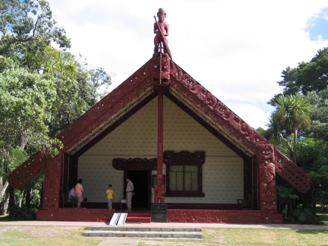
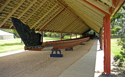
The treaty grounds are a very historical site for the people of New Zealand, and we will be visiting them on January 6th. Here, visitors can take different tours of the grounds and immerse themselves in the history of the country. There are also demonstrations and shows for entertainment. This area is rich with history and has multiple displays of artifacts from past tribes. The Treaty House, which is now a museum, was home to James Busby, a British "watchdog". He inhabited it from 1832 to 1844, and it was one of the first architectural British buildings. There is also the Whare Runanga, which is a Maori meeting house. It was built in 1940 to celebrate the 100th year since the signing. On Waitangi Day, February 6th, the world's largest canoe would be carried out by 80 warriors and paddled around the bay. This tradition stopped in 2005, but the canoe is on display for visitors to see. It is 35m long, which is about 115 ft, and called Ngatokimatawhaorua.
Links:
http://www.waitangi.net.nz/
http://www.nzhistory.net.nz/politics/treaty/the-treaty-in-brief
http://en.wikipedia.org/wiki/Treaty_of_Waitangi
Photos:
http://www.eske-style.co.nz/images/Maori%20Te%20Whare%20Rununga%20Waitangi%20Far%20North_B.jpg
http://farm1.static.flickr.com/147/348783694_fddb7bf3a4.jpg
http://www.panoramio.com/photo/6577064
http://www.panoramio.com/photo/416893
http://www.eske-style.co.nz/images/Maori%20Te%20Whare%20Rununga%20Waitangi%20Far%20North_B.jpg
Subscribe to:
Post Comments (Atom)
No comments:
Post a Comment